The recent viral phenomenon of iridescent clouds, commonly misidentified as "rainbow clouds" or "fire rainbows," over the regions of Bogor and Bekasi in West Java, Indonesia, provides a clear case study in atmospheric optics. When videos of the shimmering, pastel-hued clouds appeared on social media, they quickly ignited public curiosity and widespread online debate regarding their authenticity. This analysis deconstructs the event by establishing the physical variables governing the phenomenon, contrasting single-slit light diffraction with traditional rainbow refraction, and evaluating the socio-technical baseline of public skepticism in an era of hyper-realistic generative artificial intelligence. By analyzing the physical and meteorological mechanisms at play, we establish a framework for assessing similar atmospheric phenomena.
The Anatomy of the Indonesian Atmospheric Phenomenon
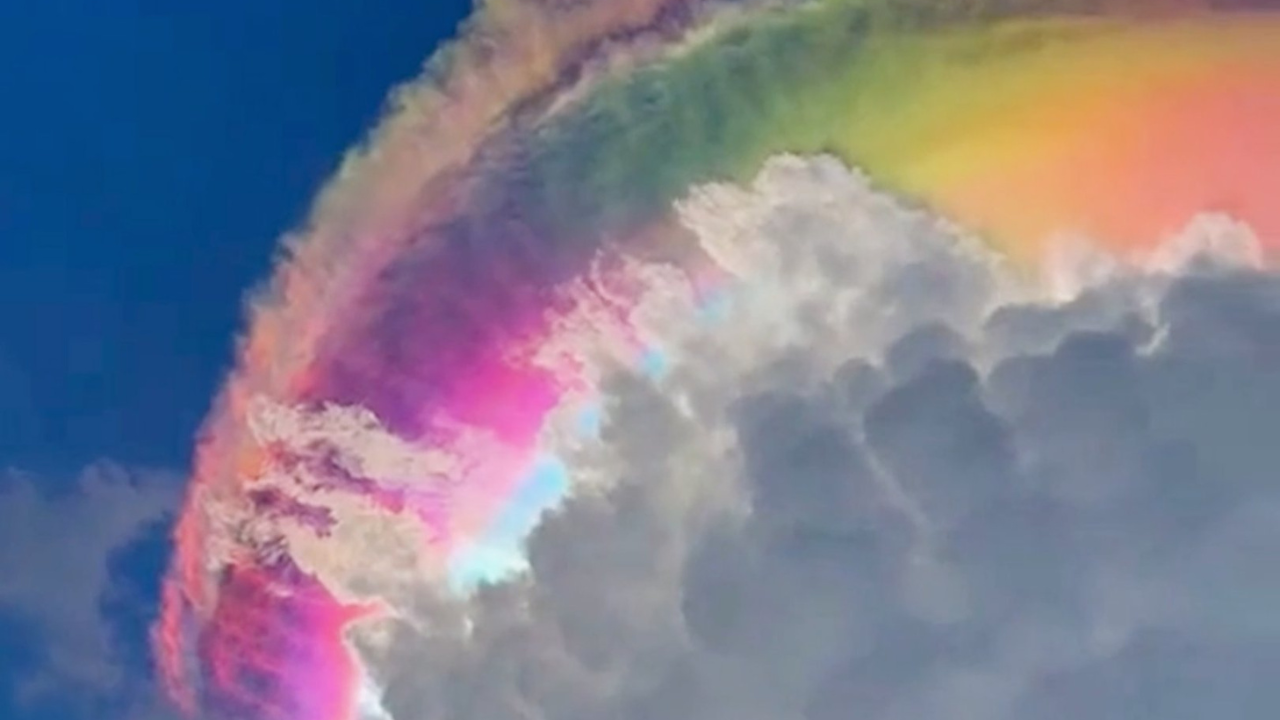
In early May 2026, residents in the town of Jonggol, located within the Bogor Regency of Indonesia, observed a brightly colored cloud formation. The event, which briefly stopped traffic, produced vivid bands of pink, green, blue, and violet along the edges of the cloud. The footage spread rapidly across platforms such as TikTok and X, racking up millions of views. Many observers immediately attributed the imagery to digital manipulation or generative AI algorithms, citing the unnatural saturation and cinematic quality of the visual display.
The Bogor and Bekasi regions of West Java, Indonesia, are characterized by tropical rainforest climates with significant orographic precipitation. The presence of nearby mountainous terrain, specifically Mount Gede Pangrango and Mount Salak, forces moist, warm air masses upward. This orographic lift cools the air adiabatically, frequently forming high-altitude, thin convective clouds. On May 1, 2026, the intersection of these geographical conditions with regional weather patterns created a setup for cloud iridescence.
At approximately 16:00 local time, residents in the Jonggol district recorded a multi-colored, shimmering cloud. The phenomenon appeared behind or adjacent to a towering cumulus cloud, which acted as an optical block, creating the illusion of an incomplete, highly localized rainbow. The visual data showed distinct horizontal and vertical patches of pink, green, and blue along the edges of the cloud. The video generated over 46 million views across social media, drawing comparisons to digital artwork and the iconic Rainbow Road from the Mario Kart video game franchise.
In response to the viral speculation, the Indonesian Agency for Meteorology, Climatology, and Geophysics (BMKG) released official statements to verify that the event was entirely natural. The BMKG's acting director of public meteorology, Ida Pramuwardani, clarified that the effect resulted from sunlight interacting with water droplets in the air. The specific formation involved towering cumulus clouds partially obscuring an underlying atmospheric optical phenomenon.
To assess the operational facts of the event, we break down the observed phenomenon into its core variables:
- Location: Jonggol and Bekasi, West Java, Indonesia.
- Date of Observation: May 1, 2026.
- Meteorological Cause: Cloud iridescence resulting from the diffraction of sunlight by small, uniform cloud particles.
- Associated Cloud Types: Altocumulus, high cumulus clouds, and lingering convective cloud edges.
The Physics of Cloud Iridescence versus Refraction
To understand the formation of these iridescent clouds, we must establish the distinction between diffraction and refraction. While the public frequently refers to iridescent clouds as rainbows, the underlying optical mechanisms differ fundamentally.
Traditional rainbows are formed through the refraction, reflection, and dispersion of light inside large raindrops, typically with a diameter of roughly 1 millimeter. When sunlight strikes a spherical raindrop, it enters the droplet, refracts, reflects off the inner back surface, and refracts again as it exits. This process separates white light into its component colors based on wavelength, creating a distinct and regular circular arc across the sky.
Conversely, iridescent clouds rely on the principle of single-slit diffraction. Diffraction describes the bending and spreading of light waves when they encounter an obstacle or aperture that is comparable in size to the wavelength of the light. In an iridescent cloud, the slits are microscopic water droplets or ice crystals suspended in the atmosphere, with diameters between 0.001 and 0.01 millimeters (1 to 10 micrometers).
When polychromatic sunlight encounters these tiny, uniformly sized droplets, the light is diffracted and separated. The degree of bending depends on the wavelength of the light and the size of the particle. The math describing this effect follows the wave theory of light, where the intensity of the diffracted light at a given angle $\theta$ is determined by the particle's diameter $d$ and the wavelength $\lambda$:
$$d \sin \theta = m \lambda$$
Where $m$ is the order of the diffraction maximum. Because the visible spectrum spans wavelengths from approximately 400 nanometers (violet) to 700 nanometers (red), the varying wavelengths create different diffraction angles. At certain angles, the waves from adjacent particles reinforce or cancel each other out, producing the shimmering bands of color.
Furthermore, we must distinguish between standard Mie scattering and diffraction in cloud droplets. While larger particles (those with a diameter significantly greater than the wavelength of light) produce scattering that is largely independent of wavelength—resulting in a white cloud—particles that are roughly the same size as the wavelength of light create sharp, angularly dependent color separation. The scattering efficiency $Q_s$ in this regime can be modeled through the size parameter:
$$x = \frac{\pi d}{\lambda}$$
For $x \approx 1$, the scattering pattern shows pronounced interference maxima and minima, which account for the distinct color separation observed in the Indonesian sky.
The Three-Variable Model of Iridescence
The occurrence of cloud iridescence is relatively rare because it requires three distinct atmospheric variables to align perfectly. If any of these variables fall outside the strict operational limits, the effect fails to manifest.
- Particle Size Uniformity: The droplets or ice crystals within the cloud must be nearly identical in size. If the droplets vary significantly in diameter, the diffraction patterns from the different particles overlap and cancel each other out. This interference results in a homogeneous white or gray haze rather than distinct bands of color. The strict requirement for particle uniformity explains why iridescence is most often observed at the very edges of newly formed clouds, where droplets have not yet coalesced into varying sizes.
- Cloud Thickness and Transparency: The cloud formation must be exceptionally thin and semi-transparent. If the cloud is thick or dense, the light is scattered multiple times or completely absorbed, preventing a clear diffraction pattern from reaching the observer. Altocumulus, cirrocumulus, and lenticular clouds provide the ideal optical density for this interaction.
- Solar Elevation Angle: The geometric alignment between the Sun, the cloud, and the observer determines the visibility of the color bands. Because diffraction angles are small, the effect is visible only when the cloud is positioned relatively close to the Sun in the field of view. The observer's viewing angle must align precisely with the diffraction maximums to perceive the colors.
We can express this optimization problem through the following functional relationship for the visibility of cloud iridescence $V$:
$$V = f(d, \tau, \alpha)$$
Where:
- $d$ is the mean particle diameter, which must remain within the 1-10 micrometer range with a variance of less than 5%.
- $\tau$ is the cloud optical depth, which must be $\tau \le 1$ to prevent multiple scattering.
- $\alpha$ is the angular separation between the cloud and the Sun, which typically falls within the 10-20 degree range.
Atmospheric Conditions and Cloud Morphology
The atmospheric conditions in West Java on May 1, 2026, created the precise thermodynamic environment required for thin, uniform clouds. The interaction between local convective activity, such as the formation of towering cumulonimbus clouds, and the high-altitude moisture profile generated thin sheets of altocumulus clouds along the periphery of the storm system.
When convective clouds grow rapidly, they displace moisture upward into the cooler layers of the upper troposphere. This rapid cooling condenses water vapor into extremely small droplets. Before these droplets can aggregate into larger rain-bearing drops, the incoming sunlight passes through the uniform medium. The presence of the storm system's rain residue and high humidity provided the necessary concentration of aerosols and water vapor.
Lenticular clouds, which form over mountainous regions like the peaks near Bogor, also generate consistent droplet sizes due to the smooth, laminar airflow over the terrain. While the Indonesian event involved cumulus clouds, the underlying mechanism of uniform droplet distribution remains identical.
The distribution of droplet sizes in a cloud often follows a gamma or log-normal distribution. The width of this distribution, measured by the standard deviation $\sigma$, determines the spectral purity of the output colors. A narrow distribution ($\sigma < 0.1$) allows the diffraction rings to remain distinct, while a broad distribution ($\sigma > 0.5$) smears the rings into an achromatic spectrum, producing a plain white cloud edge. The localized convective updrafts over Bogor created the precise updraft velocities necessary to generate a narrow droplet size distribution at the cloud boundaries.
The Socio-Technical Mechanism of AI Skepticism
The reaction to the Indonesian rainbow clouds reveals an important shift in public perception. When digital imagery can be generated by AI models with high precision, the public's baseline trust in visual media deteriorates. In this case, the highly saturated, pastel colors of the iridescent clouds caused observers to assume the footage was manipulated.
This skepticism is a direct consequence of the rapid proliferation of generative AI imagery, which has trained the public to question the authenticity of unusual visual phenomena. The reaction highlights the growing gap between scientific literacy and digital media literacy.
To deconstruct this phenomenon, we categorize the elements driving public distrust into three components:
- Visual Unfamiliarity: Observers rarely encounter iridescent clouds in their daily lives, making the visual data appear alien.
- Hyper-Realistic Generative AI: The ubiquity of synthetic video tools has lowered the threshold for doubting real-world imagery.
- Information Diffusion: Social media algorithms reward viral, high-contrast content, encouraging assumptions of digital alteration rather than scientific explanation.
We can quantify the public skepticism $S$ regarding the authenticity of unusual atmospheric phenomena through the following equation:
$$S = \beta_1 V_u + \beta_2 E_{ai} + \beta_3 I_d$$
Where:
- $V_u$ is the quantified rarity or unfamiliarity of the optical event to the observer.
- $E_{ai}$ is the adoption rate and realism of generative synthetic media.
- $I_d$ is the velocity of information dissemination across social media platforms.
- $\beta_1, \beta_2, \beta_3$ are the respective coefficients of influence for each parameter.
Because $E_{ai}$ has increased rapidly over recent years, the overall skepticism threshold has shifted downward, meaning that extraordinary real-world phenomena are now systematically evaluated under the assumption of simulation or manipulation.
The Mechanics of Public Trust in Natural Phenomena
The BMKG's intervention highlights the necessity of scientific communication in maintaining institutional trust. When an unusual visual event occurs, official meteorological agencies serve as the primary arbiters of reality.
The BMKG used its infrastructure to measure and verify that the Indonesian rainbow clouds were a real-world event. By explaining the optical mechanics, the agency shifted the conversation from speculation about digital manipulation to scientific education. The event serves as a blueprint for how public institutions can counter the effects of media skepticism.
The institutional validation process proceeds as follows:
- Data Acquisition: Retrieving real-time satellite imagery and local meteorological station readings to check cloud layers.
- Verification: Confirming the presence of thin, high-altitude clouds along the periphery of convective cells.
- Public Communication: Disseminating the physics of diffraction to replace unverified assumptions with verifiable facts.
Strategic Forecast
As generative AI tools become more integrated into media creation, the frequency of public skepticism regarding natural anomalies will rise. Meteorological organizations must adapt their communication strategies. Future frameworks for validating atmospheric events should include real-time data dashboards, open-source satellite imagery, and accessible explanations of optical phenomena.
The strategic play is to build an early-warning system that combines real-time satellite imaging with public outreach before an unusual event goes viral. By preempting the social media cycle, institutions can ensure that the public understands the scientific reality of such phenomena.